Colorado's Sangre De Cristo
COLORADO'S SANGRE DE CRISTO
Trailing The Rockies
HAROLD MORTON
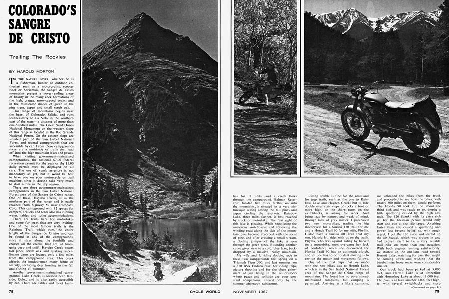
TO THE NATURE LOVER, whether he is a fisherman, hunter or outdoor enthusiast such as a motorcyclist, scooter rider or horseman, the Sangre de Cristo mountains present a never - ending array of beauty in the many rock formations of the high, craggy, snow-capped peaks, and in the multicolor shades of green in the pine trees, aspen and small scrub oak.
This range of mountains begins near the heart of Colorado, Salida, and runs southeasterly to La Veta in the southern part of the state - a distance of more than one-hundred miles. The Great Sand Dunes National Monument on the western slope of this range is located in the Rio Grande National Forest. On the eastern slope are situated part of the San Isabel National Forest and several campgrounds that are accessible by car. From these campgrounds there are a multitude of trails that lead off into the - high mountain lakes and passes.
When visiting government-maintained campgrounds, the national $7.00 federal recreation permit for the year or the $1.00 daily permit must be displayed on all cars. The use of spark arrestors is not mandatory as yet, but it woud be best to have one on your motorcycle or trail machine, since it doesn't take very much to start a fire in the dry season.
There are three government-maintained campgrounds in the San Isabel National Forest area of the Sangre de Cristo range. One of these, Hayden Creek, is in the northern part of the range and is easily reached from highway 50 near Cotopaxi, Colo. This campground with 12 spaces for campers, trailers and tents also has running water, tables and toilet accommodations.
There are trails here for motorbikes and some for jeeps that are very inviting. One of the most famous trails is the Rainbow Trail, which runs the entire length of the Sangre de Cristos and can be found at any of the campgrounds, since it stays along the foothills and crosses all the creeks, that are, at times, quite deep and swift. Hayden Creek boasts tall pines, scrub oak and quaking aspen. Beaver dams are located only a few miles from the campground area. This creek affords the outdoorsman many forms of activity, including deer hunting in the fall and fishing all summer.
Another government-maintained campground, Lake Creek, is located near Hillside, Colo., and is also easily accessible by car. There are tables and toilet facilities for 11 units, and a creek flows through the campground. Balman Reservoir, located five miles farther on into the mountains, is situated in a very picturesque setting among the tall pines and aspen circling the reservoir. Rainbow Lake, three miles farther, is best reached by truck or motorbike. The first sight of this lake is pleasing. While negotiating the numerous switchbacks and following the winding road along the side of the mountain, you become absorbed with the scent of pine, and after crossing a small stream, a fleeting glimpse of the lake is seen through the green pines. Rounding another curve gives view to a cold, blue lake, backdropped by a massive, rocky mountain.
My wife and I, riding double, rode to these two campgrounds this spring on a Triumph Tiger 500, and last summer, on a 350 BSA Enduro Star, for riding trips, picture shooting and for the sheer enjoyment of just being in the out-of-doors where peace and solitude are your constant companions, altered only by the summer afternoon rainstorms.
Riding double is fine for the road and for jeep trails, such as the one to Rainbow Lake and Hayden Creek; but to ride double over stair steps of rocks a foot or more high, or the sharp turns on the switchbacks, is asking for work. And being lazy by nature, and weak of mind, through lack of gray matter, I purchased two new motorbikes, trading the big motorcycle for a Suzuki 120 trail for me and a Honda Trail 90 for my wife, Phyllis. I also have a Suzuki 80 Trail that my son, Harold Jr., rides with us on the trails. Phyllis, who was against riding by herself on a motorbike, soon overcame her lack of confidence when she discovered the Honda Trail 90 has an automatic clutch, and all one has to do to start moving is to rev up the motor and movement follows.
One of the first trips that we made with the new bikes was to Hermit Lake, which is in the San Isabel National Forest area of the Sangre de Cristo range of mountains. The forest has no governmentmaintained campsites, but camping is permitted. Arriving at a likely campsite,
we unloaded the bikes from the truck and proceeded to see how the bikes, with nearly 500 miles on them, would perform. The Honda 90 took fire on about the third kick and was ready to go, despite a little sputtering caused by the high altitude. The 120 Suzuki with its extra rich jet for the break-in period would only start and run at the idle speed. Anything faster than idle caused a sputtering and power loss beyond belief; so, with much regret, I put the 120 aside and started up the 80 Suzuki, which was broken in and had proven itself to be a very reliable trail bike on more than one occasion. With both engines running satisfactorily, we started up the one-lane road toward Hermit Lake, watching for cars that might be coming down and wishing that the baseball-size loose rocks were considerably smaller.
Our truck had been parked at 9,000 feet, and Hermit Lake is at timberline with Horseshoe Lake at about 11,000 feet. The pass is at least another 1,000 feet higher, with several switchbacks and steep (Continued on page 91) grades all the way to the summit. On the other side of the pass lies Rito Alto Lake, which is also at timberline, and presents one on the most pleasing scenic views in the area. That day Phyllis and I made two trips to the sight of this lake in Rio Grande National Forest, in an effort to help her become familiar and more at ease with the operation of the Honda.
To gain more experience at trail riding we next chose Macey Lakes, one of several that can be reached from the Rainbow Trail by taking off at the appropriate forest service sign. Macey Lakes trail proved to be fairly easy until the last half-mile, where rocks lined the trail; high centering was a common problem, along with a marsh bog that could be quite a problem — especially in the early summer when the snow is melting. Reaching the lake, which is nestled in a large valley, signs of severe cold winds were prominent, since most of the trees are smaller and weather beaten. Some were bleached to an offwhite, resembling piles of deer antlers. This ride convinced us that now was the time for a ride over one of the most spectacular and adventuresome trails in the Sangre de Cristo range — the Phantom Terrace and the accompanying Comanche Lake and Venable Lake trails that start at Alvarado Campgrounds.
The third and largest campground, Alvarado, has 44 campsites for tents, campers or trailers with water faucets, tables and toilet facilities. It is easily reached by going south from Westcliffe, Colo., three miles on highway 69, then six miles west from the highway road sign.
Reaching Alvarado one bright, Fall Monday morning, Phyllis and I unloaded the motorbikes, both of which had been geared for the trail and proven to be satisfactory in the previous ride to Macey Lakes. The Suzuki 120 had a 70-tooth sprocket on the rear and the Honda had the regular 68 -tooth on the back. In addition to this we carried an extra spark plug and a spare master link in case troubles developed in this area. The 120 had been rejetted to where it ran without hesitation, after it was warmed up to operating temperature. So, we headed the bikes up the trail to Comanche Lake, since this puts the Phantom Terrace on the downhill side of the ride. This threemile ride to the lake is very enjoyable since there is plenty of room on the switchbacks and the inclines are not steep enough to necessitate any fast speeds in order to maintain your momentum. After topping a rise from the switchbacks, the trail follows the side of the mountain for about a mile, with an occasional rock slide crossing that makes for more bounce than anything else. Once at Comanche Lake, the pass is visible as is part of the trail that leads to it.
Continuing on from the lake, the trail unfolds along the side of the mountain as you proceed from one curve or switchback to another; only when you reach the crest of Comanche Pass do you see the last of the climb vanish over the summit, and upon looking back, the lake has decreased in size to a small pond. The
mountain to the left of us seemed so close that it was almost mandatory to get to the top of at least one of these 14,000 foot gigantic pieces of rock, if for no other reason than self-satisfaction. So we parked our bikes and hiked, because no trail was there and the seemingly smooth side of these mountains is very deceptive, since innumerable holes and jutting rocks appear so frequently that they can only be appreciated after one has tried the fine art of trail blazing.
The view from this splendid vantage point is great, to say the least. To the west can be seen the Crestone Needles, a group of sharply jagged mountain spires, to the north can be seen famed Pikes Peak, a distance of over a hundred miles, and to the south, a view of the present mountain range, with row after row of mountains receding into the distant plains, and, finally, to the east a view of Comanche Lake with the Wet Mountains in the far distance. The time required for this extra jaunt to the top of the mountain was a little over an hour, because several rests were needed in order to fill our lungs, since at 13,000 to 14,000 feet, the air is there, but certainly not in great quantity.
Upon descending to where the motorbikes had been left, we took note of the Forest Service signs stating that Crestone Lake is seven miles down into the Rio Grande National Forest. We had come five miles from Alvarado Campgrounds. Also, Venable Lakes was two miles distant and our objective, Phantom Terrace, was only one mile away. This one mile was traversed in record" time, since both of us were anxious to see the Phantom Terrace and were accustomed, more or less, to riding on the side of the mountain by this time. So, after coming to the crest of the trail, where a rocky ledge could be seen with over a thousand foot vertical drop — at times winding its way precariously along the side of the mountain down into the valley of the Venable Lakes — Phantom Terrace was before us. Both of us eased out onto a ledge which is actually quite wide, and if it hadn't been for the rock stair steps every so often, and the height, our worries would have been eased considerably.
Needless to say, this section of the trail was not traveled in record time, as our ride down to the Venable Lakes took close to an hour of suspense-filled braking and bike-walking, with an occasional climb over a small rise that required an immediate application of brakes once over it, to keep our momentum down. Speed under these conditions was not our desire.
Reaching Venable Lakes, we took time out for a much-needed rest and a belated lunch of sandwiches that had been wrapped in our extra coats on the luggage carriers, and it proved to be very satisfying, especially in these surroundings.
A cool mountain breeze, accompanied by the warmth of the late-afternoon sun, reminded us that the day would soon be ended. So, with reluctance we headed our mountain-climbing, small, two-wheeled trail machines down the now comparatively easy three miles of trail to the Alvarado Campground, and thence home. ■