Not Sturgis 2015
NOT STURGIS 2015
THE ANTISOCIAL BIKER RALLY OF ONE
Peter Jones
I WENT TO STURGIS, BUT NO ONE WAS THERE. THAT’S BECAUSE I WENT IN JUNE. THIS WASN’T BY ACCIDENT.
A good half-dozen times I’ve attended the motorcycle rally that’s colloquially called Sturgis. Each time I come away with an unfulfilled curiosity about western South Dakota. In the fog of 300,000 to 400,000 motorcyclists, it’s impossible to experience the authentic character of the region. Yet beneath the rumbling haze of din and spectacle, there’s a hint that it’s a special place. There’s a hint of something.
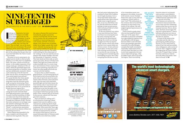
This year marked the 75th motorcycle rally that’s been taking place in Sturgis. But Sturgis isn’t just the name of a small town of 6,500 in western South Dakota. For a week each year it’s the name of the largest community in that entire state, with an estimated population of 400,000. During that week, Sturgis isn’t just a single, static town; it’s a whole region. It starts in Wall, South Dakota, near the Badlands, and extends west to Devils Tower, Wyoming. It’s bordered on the north by Belle Fourche and on the south by Hot Springs, encompassing more than 12,000 square miles of buttes and bluffs, needles, hoodoos, and what-have-yous. And in the middle of it stand
the majestic and mysterious Black Hills. So just what is this thing called Sturgis when it’s not this thing called Sturgis? I had to know.
ENCOMPASSING MORE THAN 12,000 SQUARE MILES 0F BUTTES AND BLUFFS, NEEDLES, HOODOOS, AND WHAT-HAVEYOUS. AND IN THE MIDDLE 0F IT STAND THE MAJESTIC AND MYSTERIOUS BLACK HILLS.
SO JUST WHAT IS THIS THING CALLED STURGIS WHEN IT’S NOT THIS THING CALLED STURGIS? I HAD TO KNOW.
For my ride, I picked up a nice blue 2015 Road Glide from Black Hills Harley-Davidson. There was my first evidence that Sturgis was only yet far distant thunder. The expanded acres of pavement surrounding the dealership, which itself recently tripled in size, was mostly vacant. Black Hills Harley-Davidson is a must-stop for many riders attending Sturgis, located right off Interstate 90, just north of Rapid City. On any day during the event its parking area is an ocean of motorcycles, with Harley baggers heartily dominating the count.
I’d never before ridden this model of HarleyDavidson, with its frame-mounted fairing, just reintroduced into the lineup after taking a year off.
I was concerned it might feel weird not having the fairing move with the handlebars, but it took about two seconds to get comfortably accustomed to the Road Glide.
A night in Rapid City at the Hotel Alex Johnson put me into the right frame of mind. Built in 1928, a year after sculpting began at Mount Rushmore, the hotel has a Native American interior motif. The lobby has life-size castings of heads in full headdress, and mosaic tiling on the floor and chandelier is ornamented with swastikas. These swastikas tend to shock the uninformed, not knowing that they’re an archetypal symbol dating from Neolithic times.
Thursday night in Rapid City is party night. All summer long. Art Ally is lined with vendors, while a full sound stage blocks 7th Street. The packed crowd is a mix of locals, near-locals, and tourists, many sporting cowboy hats but few wearing black T-shirts.
Some 40 miles north, Sturgis on a June Friday morning is a dusty agricultural town. Lazelle Street, the primary boulevard through Sturgis, almost looks normal, except for an unusual number of large parking lots. The famous Knuckle Saloon was open for business, and there was even a vendor set up on the corner selling T-shirts. Weirdest of all, Main Street had cars and pickups parked on it. Plus one blue motorcycle.
We met with Mayor Mark Carstensen on the corner of Main and Harley-Davidson Way, which was formerly 2nd Street. On the northwest corner on the intersection the Harley-Davidson Rally Point was busily under construction, scheduled for dedication July 31,2015.
Carstensen has been mayor of Sturgis since 2011. Shortly after he was elected, a new city manager was appointed, and they drafted an economic development plan that is now bearing fruit. “As far as City Hall goes, we’re working on the rally all year round. About 70 percent of the time that’s what we’re working on.
“We’ve created new ordinances with the goal of downtown revitalization. We want yearround business—business that will invest in the community. Like this rally point funded by Harley. The city owns it, but we were able to build it without city funds. It’s not just for them for the rally. It’s for the city. It will have a fireplace, benches. It’s a meeting place for us. Our Christmas tree will be there. It’s for the city.”
When asked how much money the rally brings into the city of Sturgis, Mayor Carstensen said,
“The number that’s used is statewide because the impact is that wide. It’s a billion dollars that’s estimated to come into the state each year due to the rally. Sturgis is only so big, so the rally covers a lot of other ground. And it’s a big state to cross, so the benefit is statewide.”
THEMAIN POINT OF THIS JOURNEY THOUGH ISN’T TO DWELL ON EMPTY LOTS AND DESERTED STREETS; IT’S TO ENGAGE IN THE MANY PLACES ACROSS THE REGION THAT ARE CHOKED WITH BIKES AND BIKERS DURING THE EVENT, TO SEE WHAT THEY’RE REALLY LIKE.
Doing some quick math in my head, it would take 400,000 bikers spending $2,500 each to arrive at a billion dollars. For a five-night stay, plus food, beer, event tickets, beer, gas, and beer, $2,500 per attendee seems a reasonable guess. But what about the thousands of vendors, and vendor fees, and taxes, and... I think a billion dollars is a low estimate. For Sturgis, the V of “twins” is V for “victory.”
The mayor joined us for a stop at the fairgrounds, located on a low bluff just a few blocks from the city center. It’s where the first Black Hills Classic was held, founded by Clarence “Pappy” Hoel and the Jackpine Gypsies. The short-track racing took place on this dirt half-mile. Like every long-standing rally, racing was the core excuse that the Sturgis rally was built around. But the 75th will be the last rally that this short track will see; the fairgrounds are being relocated east of the city.
“A half-mile track, an MX track, and rodeo grounds that are separate are going to be built,” Carstensen said. “This area will be purposed differently, with households. We have a VA hospital that’s a big economic driver for us. That’s what the housing here will be for—for families to move here, work here, live here.”
The main point of this journey though isn’t to dwell on empty lots and deserted streets; it’s to engage in the many places across the region that are choked with bikes and bikers during the event, to see what they’re really like. The purpose is to smell the sweet grass, pet a buffalo, wrestle a mountain goat. Maybe buy a cowboy hat.
On the high prairie just east of Sturgis stands the imposing Bear Butte. It dominates the northern horizon of famed, party-central Buffalo Chip. It’s a majestic, igneous anomaly, rising about 1,200 feet above the prairie. It was, and still is, sacred to the many tribes of the Sioux and Cheyenne. In 1857, an estimated 10,000 Sioux gathered there to plan their future. Red Cloud, Sitting Bull, and Crazy Horse were there. It’s where the Creator communicates to Native Americans; as was their way, it’s basically a church built by the Creator.
In many places in this region—Bear Butte, Black Hills, Devils Tower—prayer cloth and tobacco pouches hang from trees. These are religious offerings and must be left undisturbed. Without getting into the current politics or disputes of this region, please note that many sites in western South Dakota are sacred to the Sioux, and the Sioux still live in the area.
Devils Tower is an exposed magma plug. Its unpleasant-sounding description doesn’t do justice to its monolithic magnificence. It lords over the surrounding bluffs with authority, standing shockingly steep and tall, built out of weirdly angled pillars. It almost makes no sense that it exists.
Devils Tower is a mistranslation of the Lakota Sioux name Mato Tipi, which means Bear Lodge. Of course, it’s sacred—like another natural-born church. It’s the sort of geological feature that could make a believer out of a doubter.
We had approached Devils Tower from Belle Fourche. Don’t do that. Take Route 14 from Sundance. Approaching Devils Tower from that route shows it standing out in full blossom against its surroundings. From Sundance the road crosses high ground, providing grand views for many miles before you arrive.
Spearfish Canyon is an inconvenient route to take from the northern edge of the Black Hills down to Deadwood. Fortunately, riding in the Black Hills is all about enjoying inconvenient routes. Route 14A originates in the city of Spearfish, where summer party night is on Fridays. The route follows the floor of a narrow canyon that winds its way for a dozen miles into the hills, passing by Bridal Veil Falls.
Deadwood is the party town of South Dakota. By luck, we’d arrived on the weekend of the Wild Bill Days. For an authentic experience, we stayed in the Franklin Hotel, which is the historic hotel of the Silverado Casino.
Two blocks of Deadwood’s Main Street were blocked off, with local bands warming up the crowd for Crystal Gayle. Unlike Sturgis, Main Street in Deadwood is thriving year-round, with barely a storefront unoccupied. Plus, nearly every building is from the 19th century, with the new ones designed to complement the historic attitude of the town, its street paved in brick.
DON’T RIDE A MOTORCYCLE AFTER DARK THROUGH OPEN BUFFALO RANGE. THEY ARE PERFECTLY CAMOUFLAGED TO BE COMPLETELY INVISIBLE AFTER DUSK. THEIR DARK, FLUFFY FUR SUCKS IN THE GLOW OF HEADLIGHTS, MAKING THEM APPEAR AS EMPTY SHADOWS AGAINST BLACKNESS.
IT’S REAL, IT’S FAKE, IT’S CARVED IN STONE, IT’S BEEN IN MOVIES, AND IT’S THE LARGEST STONE CARVING THAT YOU’LL EVER SEE (UNLESS YOU DRIVE 17 MILES SOUTHWEST TO THE CRAZY HORSE MONUMENT).
Of course, the Wild Bill that this event refers to is Hickok, who famously got dead in Deadwood, leaving a curse on a hand of aces and eights since early August of 1876. Across the street from where he was shot, and a block south, is the No. 10 Saloon.
It has a chair on display that is claimed to be the one Hickok was sitting in when he died. It’s a completely unsubstantiated claim.
We had some beverages there, while sitting next to a couple from Sioux Falls who were celebrating their 20th wedding anniversary. She works in upper management at a corporation while he, in her words, “...earns his living on the back of a horse.” A cowboy.
She continued, “You should see him there, talking to the horses, learning who they are. When I see him doing that... There is no other man.”
Here they were, celebrating 20 years of marriage, in the same silly, rowdy, cowboy bar where they’d spent their wedding night. She pointed out to me an old framed photo high on one wall, of an unknown frontier woman. She said that her husband and her vowed their love to each other in front of that picture on their wedding night and that whenever they return they repeat the vow.
There I was, sitting with a photographer I’d never met before, yet otherwise in life alone, wondering why I’d gotten my dream of that so wrong so many times.
“Barkeep, I’d like another beer.”
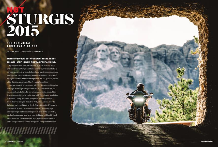
MOUNT RUSHMORE. It’s real, it’s fake, it’s carved in stone, it’s been in movies, and it’s the largest stone carving that you’ll ever see (unless you drive 17 miles southwest to the Crazy Horse Monument).
It was created by Gutzon Borglum, who was the original sculptor of the Confederate Memorial on Stone Mountain in Georgia. He walked off that job following a dispute with that project’s funders but not until after he’d developed the tools for making big sculptures.
Route 16A, heading south from between Mount Rushmore and Keystone, is unlike any other road in the USA. It has three Pigtail Bridges and narrow tunnels. The Pigtail Bridges are curves of more than 360 degrees, looping the roadway over the top of itself.
The tunnels were purposely carved to frame straight at Mount Rushmore, for travelers heading north. So be sure to stop and look back if you’re going south. The route is tight and slow going but provides an intimate cruise through the granite spires and tall pines of the Black Hills.
Custer State Park covers much of the southern Black Hills. It’s a place where buffalo roam free. It’s also where mountain goats live, particularly in the Needles Highway area. The goats are brash, beastly, wild-eyed, and up to no good. They have horns. They’re tourists, just like you and me. Well, actually, they’re escapees. They were brought from the Rocky Mountains to a fenced enclosure in Custer State Park in the 1920s. All six of them escaped within a matter of weeks. They or their children have been committing incest all across the Black Hills ever since. So they’re a bit demented.
Just last decade, two new groups of goats have been introduced to these inbreeders, to try to diversify the gene pool. Word is that the project has been effective. The goats likely won’t attack you, but they do love climbing things. Shiny, chromed motorcycles can be very attractive to them.
Buffalo also roam freely in Custer. They’re actually bison, but we’re going to call them buffalo because, well, hey, most of us still call Native Americans Indians, and that’s a miss by half a world, proving that we don’t really care what we call something. Plus, if we don’t maintain the misnomer it creates all kinds of problems: Bison Bill?
Don’t ride a motorcycle after dark through open buffalo range. They are perfectly camouflaged to be completely invisible after dusk. Their dark, fluffy fur sucks in the glow of headlights, making them appear as empty shadows against blackness. A mature male weighs about a ton, and most of that weight is muscle. They can run up to 40 mph. In a dragrace, a buffalo will likely beat your 6o-foot time. To them, the revving thunder of a big twin is a growl of challenge. A buffalo will accept a challenge.
The Crazy Horse Monument is beset with controversy even among Native Americans. It was commissioned by an Oglala Lakota Sioux chief, but, to many, it violates the sensitivities of Sioux culture. Carving a sculpture into mountain in the sacred Black Hills is considered sacrilegious by some. Additionally, it goes against any plausible wishes of Crazy Horse himself, a warrior who successfully never allowed a picture to be taken of him. So this monument isn’t even really of Crazy Horse; it’s an interpretive dramatization of him, at best.
GEOLOGICALLY, THERE’S SOMETHING UNEXPECTED AND WEIRD AROUND EVERY CORNER. EXPERIENCING THAT FOR A FEW DAYS CAN CHANGE YOU IN THE BEST WAY THAT TRAVEL CAN. ...IF YOU LET YOURSELF BE CONSUMED BY ITS STARTLING FEATURES, AND FEEL ITS PULSE, IT BECOMES EASY TO UNDERSTAND WHY SO MUCH OF IT IS SACRED.
Some, though, realize that fighting it would be just one more battle to lose, while yet others see it as an apt response to Mount Rushmore and a way for the Sioux to reclaim the Black Hills. Two things about it that are certain: It’s large, and you and I will be dead before it’s completed.
Wind Cave National Park is at the Southern end of the Black Hills, covering an area of high, rolling prairie, where the grass was never tall like that on the Great Plains. Few attendees of the Sturgis rally make it this far south during the event, but those who do are rewarded by scenery that’s unique in yet a different way from the uniqueness of places already described. The speed limit seems unreasonably low, but that’s because there are buffalo on the highway.
Wind Cave itself is something to see. It’s a network of miles of natural tunnels. The park offers a number of guided tours from which to choose.
The cave was named for the remarkable breeze through its entry way, caused by a large volume of air exchanging through such a narrow opening due to the difference in temperature above and below ground, and the size of the cave.
Were there a western South Dakota community that I’d invest in, it’d be Hot Springs. From a quick ride through town, it appears to have more closed businesses than open ones. But as is often the case, that same lack of money is what has saved its history. Its main avenue has some of the best examples of western mountain 19th century stone architecture.
Strangely, Hot Springs, a town with a population of less than 4,000 and that’s 70 miles from the nearest interstate or airport, is where the yearly Miss South Dakota pageant takes place.
East of the Black Hills and Rapid City are the Badlands, which are beautiful in their ugliness. Once a giant sea, followed by successive flood plains and riverbeds, it’s now a site of active erosion of tens of millions of years of sediment. It’s unfriendly yet inspiring. The Badlands yield huge amounts of fossils, dating from about 30 to 70 million years ago, including little horses that one time grazed this continent.
Again, like so much of the region, the Badlands are unique in a way completely different from the rest of this region that’s packed with unique geological treasures. Badlands can be accessed from a number of directions, but a ride through it from the southwest to the north provides the best tour. After traversing the White River Valley and Pine Ridge Indian Reservation, the loop of Route 240 to Wall gives a broad perspective of the Badlands from atop its northern ridge.
In all, western South Dakota is enthralling. Geologically, there’s something unexpected and weird around every corner. Experiencing that for a few days can change you in the best way that travel can. It’s a place where Planet Earth has been active and inventive. If you let yourself be consumed by its startling features, and feel its pulse, it becomes easy to understand why so much of it is sacred. It’s a place of dynamics and drama. It’s a place that cannot be truly experienced during the congested cacophony of celebrating bikers. It requires many stops, walks, quiet, and a full immersion to comprehend.
I’ve never been much for anthropomorphizing the natural world. What I’ve learned on this journey is to make an exception for that. For Native Americans, there’s no other plausible way to experience or comprehend the earth we live on than to respect it as a living being. In western South Dakota, the Black Hills embrace you with their comforting scale. You can feel the earth breathing against you at Wind Cave—sometimes inhaling, sometimes exhaling.
You can see the anger in the Badlands. You can touch the sky above the prairie at Bear Butte.
Added together, this region’s diverse extremes work on you with their conflicting excitements.
Like a beachhead against an ocean or a convergence of two powerful rivers, it’s where air meets rock with drama. It’s a place that moves men’s hearts, just through the magic of its natural morphology. After a couple of days in the Black Hills, you can feel it inside you.
At dusk on one evening, we were trying to reach Hot Springs before twilight ended, concerned to be out among the buffalo while riding a motorcycle after dark. But despite that, and despite being tired, despite being exhausted from another day of intense experiences, I stopped on the roadside in the rolling hills of Wind Cave. I stopped because we’d found what the region is, and I had to let us pause again to let it envelop us in silence. The thunderhead of a hailstorm covered the eastern sky, pink at its top miles above where the sun was still shining. Breezes drove waves across the lush grasses. The red western sky colored the air in gold. Wild animals grazed in the distance. I wondered if maybe the point isn’t to invest human qualities into nature but the other way around.